ANATOLY IVANOV / PROSE / 2009-05-29
OUTDOOR 2008: GARMIN OREGON TOUCHSCREEN GPS PREVIEW
BACKPACKING / CLIMBING / CYCLING / GADGETS / TRANSPORTATION / PREVIEWS
You are reading a 2008 preview. Read a detailed hands-on 2009 review.
A new top of the line Garmin outdoor GPS? No antenna? No buttons? No thumbwheel?
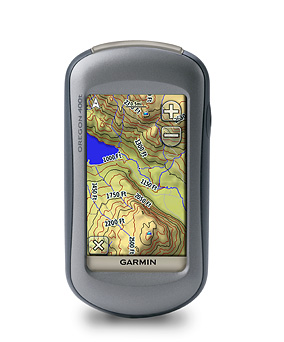
Photo: Garmin Oregon GPS unit / Used with permission from Garmin / Author unknown
WHAT’S NEW AND INTERESTING?
The new Garmin Oregon GPS looks very similar to the Garmin Colorado GPS. I almost missed it at the Garmin booth during the Friedrichshafen European Outdoor 2008 show.
The main differences are the user interface, dimensions and weight.
// Touchscreen
Click and drag the map with your fingers. Add waypoints with a thumb. The Oregon is much easier to use than the Colorado’s buttons and scroll-wheel. But still, the Oregon is far from iPhone’s responsiveness and Wow! effects.
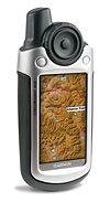
Photo: Garmin Oregon touchscreen display / Used with permission from Garmin / Author unknown
// Weight
The Oregon is lighter!
// Dimensions
The Oregon is smaller!
SPECIFICATIONS AND FEATURES
- Manufacturer: Garmin (garmin.com)
- Model: Oregon 400
- Year: 2008
- Materials: plastic body, silicon chips, metal wiring
- Main features: color touschscreen display, high-sensitivity GPS receiver, microSD card slot, barometric altimeter, compass
- Size (width x height x depth): 6 x 11,5 x 3,5 cm (2.3" x 4.5" x 1.4")
- Weight: 193 g (6.8 oz) with 2 AA NiMH batteries (manufacturer specification)
AVAILABILITY
Should be in stores worldwide this autumn 2008.
GARMIN OREGON VS GARMIN COLORADO COMPARISON
The Oregon and the Colorado are so similar (except for the user interface), it’s natural to compare them:
 Garmin Colorado 400 |
 Garmin Oregon 400 |
|
|---|---|---|
| Dimensions: (width x height x depth) |
6 x 14 x 3,5 cm (2.4" x 5.5" x 1.4") |
6 x 11,5 x 3.5 cm (2.3" x 4.5" x 1.4") |
| Prominent antenna: | yes | no |
| Display size: | 3" diagonal (7,6 cm) | 3" diagonal (7,6 cm) |
| Display resolution: | 240 x 400 px | 240 x 400 px |
| Display type: | Transflective color TFT | Transflective color TFT touchscreen |
| User interface: | Thumbwheel and buttons | Touchscreen |
| Weight: | 207 g (7.3 oz) with batteries |
193 g (6.8 oz) with batteries |
| Battery: | 2 AA batteries | 2 AA batteries |
| Battery life: | 15 hours | 16 hours |
| Waterproof: | yes (IPX7) | yes (IPX7) |
| High-sensitivity receiver: | yes | yes |
| Connection interface: | USB | USB |
| Accepts data cards: | SD card | microSD card |
| Compass: | yes | yes |
| Barometer / altimeter: | yes | yes |
| Bike mount: | yes | yes |
MY QUESTIONS AND DOUBTS
// Touchscreen
In my opinion, a mapping GPS is especially useful in 2 cases: winter navigation (recognizable terrain features hidden by snow, whiteouts, glaciers) and speed cycling in unknown areas.
- Will the Oregon touchscreen still work with gloves? I couldn’t try the Oregon with my gloves on: it was a sunny +25° C.
- Will the Oregon touchscreen still respond in sub-zero temperatures? Liquid crystal displays tend to slow down in freezing temperatures. What happens to the touch-sensitiveness of the Oregon in winter?
- What will happen to the Oregon touchscreen interface in the rain?Imagine scrambling or cycling in a cloud: 1-meter visibility, torrential rain, map soaked… Oregon GPS to the rescue! Uhmm… Sliding fingers in a water puddle?
// No protruding antenna
Both the Garmin Colorado and the Garmin GPSMAP 60CSx feature a prominent antenna. The Oregon does not.
- How does the lack of external antenna affect the Oregon’s satellite signal reception?
- Is the Colorado more sensitive than the Oregon?
// Maps
I am still compiling a list of maps that will work on the Oregon.
The European Oregon 400t will sell with a preloaded 1:100 000 cm vector topographic map of Europe.
- What about the more detailed topographic maps at 1:25 000 cm? Of France? Of Switzerland?
// Mac support
Garmin’s Mac OS X page talks about “fall 2008 support for most Garmin Outdoor Handhelds with USB cables”.
- Does that mean my Mac will talk to Oregon?
// Product positioning
I puzzle over Garmin’s marketing strategy: the Oregon and the Colorado cost the same!
- Is the Oregon a replacement of the Colorado in the mid-term?
- What’s the marketing thinking behind the Oregon?
I’ve sent my questions to the Garmin team…
I also plan to get an Oregon unit to test in the near future. Or should I wait for winter?
That’s what I did in March 2009. I got both the Oregon and Colorado and reviewed them extensively.
CHANGE LOG
| 2009-05-29 | Added link to detailed review. |
| 2008-07-24 | First publication. |
ADD YOUR COMMENT
ABOUT ANATOLY IVANOV / PROSE
Find out more about my posting and comments policy, as well as publishing frequency and copyright issues.